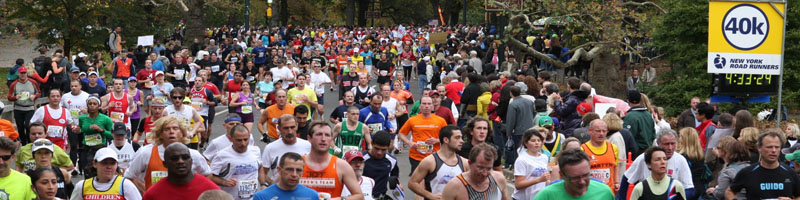
|
|

Detaljert om løypa
- I do NOT agree with the people who call the course "hilly". It's not the easiest Marathon course, but it's far from the hardest. Most of the course is very flat, with some exceptions:
- Verrazzano Narrows Bridge. That's the tallest of the bridges. It has a total elevation of about 155' (48m). The total uphill is about 0.95 miles (1.5km). The main incline is about 4.5%. But you really don't feel it much because you start at the bridge. Because of the crowds you are not able to run your own speed before you are on the top, so it's no problem at all!
- Lafayette Avenue between mile 8 and 8.5. It has a total elevation of about 58' (18m). The total uphill is about 0.6 miles (0.9km). The main incline is about 2.5%.
- Pulaski Bridge at the halfway point. It's short and no big deal. It has a total elevation of about 38' (12m). The total uphill is about 0.35 miles (0.5km). The main incline is about 3.8%.
- Queensboro Bridge. That's in my opinion hard. It has a total elevation of about 103' (31m), but since it starts right before the 15 mile mark (24km) many people start feeling it. The total uphill is about 0.55 miles (0.9km). The main incline is about 3,0%.
- Willis Avenue Bridge. It's very short, but right before the 20 mile mark. It has a total elevation of about 41' (12m). The total uphill is about 0.3 miles (0.5km). The main incline is about 3.2%.
- Madison Avenue Bridge. It's the easiest of the bridges. It has a total elevation of about 12' (4m). The total uphill is about 0.15 miles (0.3km). The main incline is about 2.5%.
- The 24th mile up 5th Avenue. It has a total elevation of about 103' (31m). It's not steep at all. On a training run you would not bother about it, but after running that long it can be very hard. Many people (including me) think that is the hardest part. The total uphill is about 0.9 miles (1.4km). The main incline is about 2.7%.
- The last 2 miles in Central Park. There are a few very short hills. But the steepest have an incline of about 4.2%.
- Many have heard bad story about the last hill ending at the finishing line. There is no reason to worry. When you start it you see the finishing line, and you get plenty of energy from that. But some facts: It's 350 yards / 320m long. The total ascent is 15 feet / 5m. Like I said it's nothing at all.
- If you want a graphical presentation of all bridges and major hills, select "Elevation Charts" from the left menu!
- The total incline on the whole course is 870' (265m)
- But remember that most of the course is quite flat :)
- Here is a description of every mile of the course!
- 1st mile. Start altitude 33m / 110 feet.
Start at the Verrazzano Toll Plaza on Staten Island. There are 3 separate starts, Blue, Orange and Pink. Blue start on the right side of the Verrazano Narrows Bridge, upper deck. Orange start on the left side, upper deck. Pink start on the left side, lower deck. The first mile is the hardest in the race with a total elevation of 50m / 160 feet for Blue and Orange. But it doesn't feel like that since it's quite crowded in the start.
- 2nd mile. Start altitude 78m / 255 feet for Blue and Orange - 70m / 227 feet for Pink.
The 1 mile mark is at the top of the bridge. From there it is downhill most of the mile. At the end of the mile we reach Brooklyn.
- 3rd mile BLUE. Start altitude 17m / 57 feet.
A small uphill. Then left on 92nd st. Another small uphill before we take right on 4th Avenue. That's where the Orange start joins, but Blue runs on the right side and Orange on the left side until the 8 mile mark. The rest of the mile is flat. And we reach the first aid station.
- 3rd mile ORANGE. Start altitude 17m / 57 feet.
A small uphill. Then left on 92nd st. And shortly after left again at Fort Hamilton Pkwy. Downhill to 95th st where we take right. Then right at 4th Avenue and an uphill to 92nd st where Blue start joins. I don't like this extra Orange loop. Blue runs on the right side and Orange on the left side until the 8 mile mark. The rest of the mile is flat. And we reach the first aid station.
- 3rd mile PINK. Start altitude 17m / 57 feet.
Continue on the Gowanus Expressway. Quite flat. Then exit at 7th Avenue and a short uphill to Bay Ridge Pkwy. Flat to 74th st where we take left. Then left on 6th Avenue. Here is the first aid station..
- 4th mile BLUE AND ORANGE. Start altitude 25m / 81 feet.
Flat on 4th Avenue until almost to the end of the mile. There we get a small uphill. The Pink start joins Blue in the first part of the mile.
- 4th mile PINK. Start altitude 25m / 81 feet.
Take right on Bay Ridge Pkwy. Flat to 4th Avenue where we take right. The Pink start joins Blue here. Flat on 4th Avenue until almost to the end of the mile. There we get a small uphill.
- 5th mile. Start altitude 25m / 83 feet.
It starts with a small uphill. Then a very flat mile on 4th Avenue. A small downhill starts right before the end of the mile.
- 6th mile. Start altitude 22m / 71 feet.
A downhill in the start and a small uphill at the end. Otherwise flat on 4th Avenue.
- 7th mile. Start altitude 12m / 41 feet.
Quite flat on 4th Avenue with a small downhill midway on the mile.
- 8th mile. Start altitude 8m / 25 feet.
Flat start before a small uphill at the end of 4th Avenue. That's where all 3 starts join. Take left on Flatbush Avenue and right on Lafayette Avenue. There is the end of this mile.
- 9th mile. Start altitude 12m / 40 feet.
The mile starts with an uphill, about 17m / 55 feet elevation. Then the rest is downhill. All on Lafayette Avenue.
- 10th mile. Start altitude 20m / 67 feet.
We take left on Bedford Avenue. It's flat for a while. Then downhill to the 10 mile mark.
- 11th mile. Start altitude 5m / 16 feet.
The mile starts with an uphill. Then a small downhill and flat before a small uphill to the end of the mile.
- 12th mile. Start altitude 17m / 55 feet.
Downhill the first part of the mile, then flat the rest. At the end of the mile turn right on Nassau Avenue.
- 13th mile. Start altitude 3m / 11 feet.
Turn left on Manhattan Avenue. Slight uphill and flat until we turn right on Greenpoint Avenue. A short downhill (8m / 24 feet) and we turn left on McGuinnes Blvd. Flat the rest of the mile.
- 14th mile. Start altitude 3m / 9 feet.
The mile starts flat. Then the Pulaski Bridge. Halfway is little over half up the bridge.
- Halfway: Start altitude 7m / 23 feet.
Continue to the top of the bridge. A total elevation of 13m / 45 feet for the Pulaski Bridge. That's the end of Brooklyn and start of Queens. The rest of the mile is flat. Take left on 48th Avenue, right on Vernon Blvd., right on 10th st and right on 44th Dr.
- 15th mile. Start altitude 3m / 9 feet.
The first part is flat on 44th Dr. Then left on Hunter st and left on Cresent st At the end of Cresent st a small uphill to the lower deck of the Queensboro Bridge where we take left. The 15 mile mark is a little up the bridge.
- 16th mile. Start altitude 25m / 82 feet.
Continue up the Queensboro Bridge. Goodbye to Queens and hello to Manhattan. The last part of the mile is down to Manhattan. The total elevation of Queensboro Bridge is 25m / 80 feet.
- 17th mile. Start altitude 24m / 79 feet.
Down from the bridge, left on 59th st, left on First Avenue. The next part is the place with the most spectators and most noise. The mile is quite flat, except from the start.
- 18th mile. Start altitude 10m / 32 feet.
First avenue. Starts with an uphill, then down and flat the rest of the mile.
- 19th mile. Start altitude 2m / 7 feet.
First Avenue. Flat.
- 20th mile. Start altitude 4m / 13 feet.
First avenue. The first part is flat. Then up Willis Avenue Bridge that leads from Manhattan to Bronx. A total elevation of 12m / 39 feet. Left on E. 135th st to the end of the mile.
- 21st mile. Start altitude 10m / 33 feet.
Take right on Alexander Avenue and a small uphill there. Then left on E. 138th st. Then they added a loop a few years ago to have the runners longer in Bronx. I don't like it. 4 90 degree turns and zero spectators. Right on Lincoln Avenue, continue on Morris Avenue, left on E. 140th st, left on Rider Avenue and right on E. 138th st. Then it's Madison Avenue Bridge. 5m / 18 feet incline. And that's the end of Bronx and we are back in Manhattan for the rest of the race. Take left on Fifth Avenue.
- 22nd mile. Start altitude 8m / 26 feet.
Fifth Avenue. Quite flat. In the end right on E. 124th st and left on Mt. Morris Park W.
- 23rd mile. Start altitude 9m / 30 feet.
Starts with left on W. 120th st, then right on Fifth Avenue. Flat until close to the end when an incline starts.
- 24th mile. Start altitude 12m / 39 feet.
Fifth Avenue. Uphill to the Central Park entrance. By many concidered the hardest part of the Marathon since it comes so late. Total elevation of the hill is 30m / 90 feet. At the end the course enters Central Park at E. 90th st and follows East Drive. It's quite flat the rest of the mile.
- 25th mile. Start altitude 33m / 108 feet.
Central Park. Up and down most of the way. Not much flat. Short hills, but can be hard.
- 26th mile. Start altitude 24m / 78 feet.
Downhill out of the park to 59th st. Then right and 59th st up to Columbus Circle. 9m / 29 feet elevation on 59th st. Turn right into Central Park for the last time. A small downhill to the end of the mile.
- 27th mile. Start altitude 21m / 70 feet.
Flat start on West Drive, then uphill the last 200m. It flattens a little in the end. The last hill has just 3m / 12 feet elevation. Nothing to bother about when you see the finishing line in front of you.
- Finish. Altitude 24m / 80 feet.
|
|
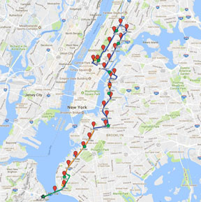
Click the map above to see my zoomable course map.
|
- You can see the official course map here.
|
|